
Pihtipudas
Pihtipudas | |
|---|---|
Municipality | |
| Pihtiputaan kunta Pihtipudas kommun | |
 | |
 Coat of arms | |
 Location of Pihtipudas in Finland | |
| Coordinates: 63°22′N 025°34.5′E / 63.367°N 25.5750°E | |
| Country | |
| Region | Central Finland |
| Sub-region | Saarijärvi–Viitasaari sub-region |
| Government | |
| • Municipal manager | Ari Kinnunen |
| Area (2018-01-01)[1] | |
| • Total | 1,247.48 km2 (481.65 sq mi) |
| • Land | 1,074.93 km2 (415.03 sq mi) |
| • Water | 172.71 km2 (66.68 sq mi) |
| • Rank | 72nd largest in Finland |
| Population (2023-12-31)[2] | |
| • Total | 3,739 |
| • Rank | 197th largest in Finland |
| • Density | 3.48/km2 (9.0/sq mi) |
| Population by native language | |
| • Finnish | 98.5% (official) |
| • Others | 1.5% |
| Population by age | |
| • 0 to 14 | 14.3% |
| • 15 to 64 | 53.1% |
| • 65 or older | 32.6% |
| Time zone | UTC+02:00 (EET) |
| • Summer (DST) | UTC+03:00 (EEST) |
| Website | pihtipudas |
Pihtipudas is a municipality of Finland. It is located in northern Central Finland on the highway 4 (E75), about 140 kilometres (90 mi) north of Jyväskylä. The municipality has a population of 3,739 (31 December 2023)[2] and covers an area of 1,247.48 square kilometres (481.65 sq mi) of which 172.71 km2 (66.68 sq mi) is water.[1] There are approximately 140 lakes in Pihtipudas municipality. The largest lakes are Alvajärvi, Lake Kolima, Muurasjärvi and Saanijärvi.[5] Kolkku lake is also in this county. The population density is 3.48 inhabitants per square kilometre (9.0/sq mi).
The municipality is unilingually Finnish.
Pihtipudas is known for the annual javelin carnival and Lauri "Tahko" Pihkala, the inventor of pesäpallo, the Finnish variant of baseball.[6] [7] The Putaanportti area offers services for travelers. Fish Art is a sales exhibition of taxidermic (mounted) fish – unique in Finland. Close to the service station there are shops – in a way factory outlets – specialized in sweets, leather bags and pottery products. Other tourist services are found in the central village and lakeside areas.
History
[edit]The area has been inhabited since the prehistoric period, evidenced by a range of Stone Age sites in the municipality, including: Niemet Keidas and Halmeniemi in the area of Muurasjärvi village; Kivikko; Pitkänen; Männikkö; Viipylä; Metsälä; Koivukangas; Rimpisuo; Santaharju; Teen; and Auhtola. [8] The so-called 'Village of Rönny' on the north-eastern shore of Saanijärvi has been dated to about 7,000 years ago. The Pihtiputa region area was inhabited by Sámi peoples until the Middle Ages. The first known fixed settlement was established in the early 16th century with the first permanent residents of Pihtiputa, Pekka Varis and Pekka Rautaparta. The main industries were fishing and hunting, complemented by the development of grain and livestock farming.[9]
Pihtipudas was first mentioned in 1552 as Pictipudhas, when it was a part of the large Rautalampi parish. By 1910 there were 286 rental farms in the municipality and 128 small farms of less than 0.5 hectares. Only 2% of the area of the municipality’s 103,771 hectares were cultivated, with 94% forested. Two-thirds of the farmed land, comprising 1,400 hectares, were owned by self-employed farms. In the early 20th century there were 246 residents for every 100 hectares of arable land.[8] Along with Kannonkoski, Kivijärvi and Konginkangas, the area was transferred to the newly established Viitasaari parish in 1635.[10]

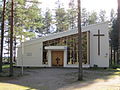
The main church in Pihtipudas was completed in 1783 and built by the peasant church builder Simo Jylkkä. The belfry was completed in 1785. Pihtipudas became an independent parish in 1863.[11] The church was renovated in 1874, 1950 and 1991.[12] The first public school in Pihtiputas was established in the village church in 1877. In 1917-18 there were 81 students. A Girl's National School was established in 1887.
In the 1940s the municipality was subject to post-war re-settlement with the introduction of migrants from 62 northern parishes, predominantly in the villages of Muurasjärvi and Kärväskylä. These included evacuees from the agricultural area of Sortavala (now in Russia) and soldiers from Ostrobothnia|.[8] As a consequence of post-war re-settlement the population grew to 8,500.[9]
On 7 March 1969 Pihtipudas was the location of a Mass shooting incident, in which Tauno Pasanen, a smallholder, shot and killed four armed policemen.[13] The incident was dramatized in the 1972 Finnish film Eight Deadly Shots.
Attractions
[edit]
A local museum and the church are situated next to each other in the center of Pihtipudas. The small museum contains examples of local prehistory, fishing, agriculture and artisan crafts.
Pihtipudas has two lakeside areas: the north-west end of Kolima lake and the south-east end of the Alvajärvi. They are connected by the Heinäjoki river, running immediately to the north of the town. Located near the bridge of Heinäjoki is a nature trail with duckboard walkways and bird watching towers. Hiekkaranta beach (meaning in Finnish: Sandy Beach) is located on the shore of the Alvajärvi at Pihtipudas, and has basic changing and toilet facilities.
The annual Pihtipudas Javelin Carnival was started in 1971 by local athletes Leo Pusa and Jorma Kinnunen. Female participation started in 1974 and a javelin school was introduced in 1975. It also includes a paralympics event. This 4-day summer festival is now the largest javelin festival in Finland, attracting regional and international athletes, including British Olympic team member Laura Whittingham. [14]

Situated 30 kilometers to the north-east of Pihtipudas is the Rillankivi boundary stone, or Stone of Rilla. This glacial erratic is believed to be one of the stones marking the border of the Hazel Island Peace Treaty (Pähkinäsaaren Rauha) of 1323.[15] This medieval boundary stone now marks the border between the municipalities of Pihtipudas, Pielavesi, and Pyhäjärvi and is protected by the Finnish Heritage Agency.[16]
Notable residents
[edit]- Erkki Ihalainen, accordian player
- Lauri Ihalainen, trade union leader and politician; Finnish Minister of Labour, 2011 and 2015.
- Artturi Jämsén, Finnish politician.
- Seppo Kahilainen, Saapasjalkarock music festival promoter.
- Esko Kananen, sculptor.
- Jorma Kinnunen, javelin athlete.
- Juhani Mustamo, energy expert.
- Ernest Paananen, Finnish-American violinist, singer, and songwriter.
- Pete Parkkonen, singer
- Tauno Pasanen, murderer
- Lauri ”Tahko” Pihkala, inventor of pesäpallo, the Finnish variant of baseball.
- Santtu Raitala, harness racer
- Ratsia, band
- Paula Vesala, singer
Twin towns
[edit] Leirvík, Faroe Islands[17]
 Borgarbyggð/Borgarnes, Iceland[18]
 Ullensaker, Norway[17]
 Dragsholm, Denmark[17]
 Falkenberg, Sweden[17]
Gallery
[edit]-
 Pihtipudas Military Cemetery
 -
 Pihtipudas Church
 -
 Muurasjärvi Church
 -
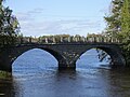 Heinäjoki Bridge


See also
[edit]References
[edit]- ^ a b "Area of Finnish Municipalities 1.1.2018" (PDF). National Land Survey of Finland. Retrieved 30 January 2018.
- ^ a b c "Population growth biggest in nearly 70 years". Population structure. Statistics Finland. 26 April 2024. ISSN 1797-5395. Retrieved 29 April 2024.
- ^ "Population according to age (1-year) and sex by area and the regional division of each statistical reference year, 2003–2020". StatFin. Statistics Finland. Retrieved 2 May 2021.
- ^ a b "Luettelo kuntien ja seurakuntien tuloveroprosenteista vuonna 2023". Tax Administration of Finland. 14 November 2022. Retrieved 7 May 2023.
- ^ "Pihtipudas". Järviwiki. Finland's Environmental Administration. 2012. Retrieved 27 February 2012.
- ^ Clair, Michael (2 August 2024). "There's a pitcher, a batter... even a river sometimes. Welcome to Finnish baseball". Major League Baseball. Retrieved 4 August 2024.
- ^ "Introduction to the game" (in Finnish). Pesäpalloliitto. Retrieved 22 September 2022.
- ^ a b c Utunen, Heini. "A short history of Muurasjärvi". Pliingpudas. Pihtiputa Municipality. Retrieved 5 August 2024.
- ^ a b "Pihtipudas History". www.pihtipudas.fi/. Pedestputa Municipal Centre. Retrieved 5 August 2024.
- ^ "Viitasaari - Tietoja Viitasaaresta". viitasaari.fi (in Finnish). Archived from the original on 12 January 2018. Retrieved 2 October 2022.
- ^ "SuomalainenPaikannimikirja_e-kirja_kuvallinen.pdf" (PDF). kaino.kotus.fi (in Finnish). p. 335. Retrieved 2 October 2022.
- ^ "The Church of Pihtiputa - Main Church". pihtiputaanseurakunta.fi. Evangelical Lutheran Church of Finland. Retrieved 5 August 2024.
- ^ Sjöström, Ralf-Erik (2008). In Memorium 1917 - 2007: Police officers killed in office. Pohjola Police Book. ISBN 9789525791013.
- ^ Tuluwami, Haile. "Carnival of Pihtipudas: Passing on the Tradition". A moment in Time. Retrieved 5 August 2024.
- ^ Lind, John (1989). Rillankivi and the Oulainen Boundary Marks– Border Stones from the Nöteborg/Orekhovets Peace Treaty (in Finnish ). Helsinki: Suomen Museo. p. 53-79.
- ^ "Rillankivi". Museovirasto. National Board of Antiquities. Retrieved 5 August 2024.
- ^ a b c d "Ystäväkuntalista" (PDF) (in Finnish). Pohjola-Norden. Retrieved 7 May 2012.[permanent dead link]
- ^ "Vennskapskommune samarbeide i Norden" (in Icelandic). Borgarbyggð Municipality. Archived from the original on 17 February 2012. Retrieved 7 May 2012.
External links
[edit]![]() Media related to Pihtipudas at Wikimedia Commons
Media related to Pihtipudas at Wikimedia Commons
- Municipality of Pihtipudas – Official website (in Finnish)
Places adjacent to Pihtipudas | |
|---|---|
| Municipalities | ||
|---|---|---|
| Former municipalities | ||
| International | |
|---|---|
| National | |
| Geographic | |
This Western Finland location article is a stub. You can help Wikipedia by expanding it. |