Tonlé Sap (river)
Appearance
(Redirected from Tonle Sap River)
| Tonlé Sap | |
|---|---|
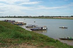
 Boats on Tonlé Sap river | |
| Native name | ទន្លេសាប (Khmer) |
| Location | |
| Country | Cambodia |
| Provinces | Kampong Thom province, Kampong Chhnang province, Kampong Cham province, Kandal province, Phnom Penh |
| Physical characteristics | |
| Source | Tonlé Sap Lake |
| Mouth | Mekong |
• location | Phnom Penh |
• coordinates | 11°33′48″N 104°56′20″E / 11.56344°N 104.93901°E |
| Length | 147 kilometres (91 mi) |
| Basin features | |
| Tributaries | |
| • left | Steung Saen River, Chinit River |
| Bridges | Prek Kdam Bridge, Prek Pnov Bridge, Chroy Changvar Bridge |
| Inland ports | Phnom Penh Autonomous Port |
Tonlé Sap (Khmer: ទន្លេសាប) is a river in Cambodia that connects the Tonlé Sap lake with the Mekong river.[1][2]
From the lake, the Tonlé Sap flows 147 kilometres (91 mi) southeast to its confluence with the Mekong river near Phnom Penh, the capital of Cambodia. During the dry season, the Mekong and Tonlé Sap rivers merge, but in the monsoon season (May to October), the Mekong's floods cause the Tonlé Sap river to reverse its flow.[2]
References[edit]
- ^ Oeurng, Chantha; et al. (25 March 2019). "Assessing Climate Change Impacts on River Flows in the Tonle Sap Lake Basin, Cambodia". Water. 11 (3): 618. doi:10.3390/w11030618.
- ^ a b Olson, Kenneth R.; Morton, Lois Wright (May 2018). "Tonle Sap Lake and River and confluence with the Mekong River in Cambodia" (PDF). Journal of Soil and Water Conservation. 73 (3).
