Lumber City, Georgia
Lumber City, Georgia | |
|---|---|
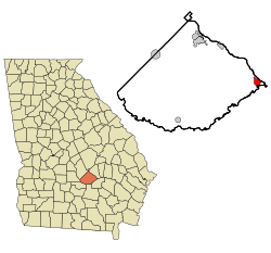
 Location in Telfair County and the state of Georgia | |
| Coordinates: 31°55′48″N 82°41′1″W / 31.93000°N 82.68361°W | |
| Country | United States |
| State | Georgia |
| County | Telfair |
| Area | |
• Total | 1.94 sq mi (5.02 km2) |
| • Land | 1.93 sq mi (4.99 km2) |
| • Water | 0.01 sq mi (0.03 km2) |
| Elevation | 138 ft (42 m) |
| Population (2020) | |
• Total | 967 |
| • Density | 502.08/sq mi (193.90/km2) |
| Time zone | UTC-5 (Eastern (EST)) |
| • Summer (DST) | UTC-4 (EDT) |
| ZIP code | 31549 |
| Area code | 912 |
| FIPS code | 13-47952[2] |
| GNIS feature ID | 0356372[3] |
Lumber City is a city located in Telfair County, Georgia, United States. As of the 2020 census, the city had a total population of 967.
History
[edit]The Georgia General Assembly incorporated Lumber City as a town in 1889.[4] The community was named for a sawmill near the original town site.[5]
Geography
[edit]Lumber City is located at 31°55'48" North, 82°41'1" West (31.930033, -82.683723).[6]
U.S. Route 23/341 is the main route through the city, and leads northwest 17 mi (27 km) to McRae-Helena, the Telfair County seat, and southeast 7 mi (11 km) to Hazlehurst. Other highways that run through the city include Georgia State Routes 19 and 117.
According to the United States Census Bureau, the city has a total area of 1.9 square miles (5.0 km2), all land.
It is located at the confluence of the Ocmulgee and Oconee rivers, which combine to form the Altamaha River.
Demographics
[edit]| Census | Pop. | Note | %± |
|---|---|---|---|
| 1890 | 471 | — | |
| 1900 | 760 | 61.4% | |
| 1910 | 1,195 | 57.2% | |
| 1920 | 978 | −18.2% | |
| 1930 | 1,043 | 6.6% | |
| 1940 | 1,044 | 0.1% | |
| 1950 | 1,232 | 18.0% | |
| 1960 | 1,360 | 10.4% | |
| 1970 | 1,377 | 1.3% | |
| 1980 | 1,426 | 3.6% | |
| 1990 | 1,429 | 0.2% | |
| 2000 | 1,247 | −12.7% | |
| 2010 | 1,328 | 6.5% | |
| 2020 | 967 | −27.2% | |
| U.S. Decennial Census[7] | |||
2020 census
[edit]| Race / Ethnicity (NH = Non-Hispanic) | Pop 2000[8] | Pop 2010[9] | Pop 2020[10] | % 2000 | % 2010 | % 2020 |
|---|---|---|---|---|---|---|
| White alone (NH) | 580 | 632 | 413 | 46.51% | 47.59% | 42.71% |
| Black or African American alone (NH) | 628 | 677 | 507 | 50.36% | 50.98% | 52.43% |
| Native American or Alaska Native alone (NH) | 1 | 1 | 2 | 0.08% | 0.08% | 0.21% |
| Asian alone (NH) | 0 | 0 | 1 | 0.00% | 0.00% | 0.10% |
| Pacific Islander alone (NH) | 0 | 0 | 0 | 0.00% | 0.00% | 0.00% |
| Other race alone (NH) | 3 | 0 | 3 | 0.24% | 0.00% | 0.31% |
| Mixed race or Multiracial (NH) | 2 | 4 | 22 | 0.16% | 0.30% | 2.28% |
| Hispanic or Latino (any race) | 33 | 14 | 19 | 2.65% | 1.05% | 1.96% |
| Total | 1,247 | 1,328 | 967 | 100.00% | 100.00% | 100.00% |
As of the 2020 United States census, there were 967 people, 494 households, and 268 families residing in the city.
References
[edit]- ^ "2020 U.S. Gazetteer Files". United States Census Bureau. Retrieved December 18, 2021.
- ^ "U.S. Census website". United States Census Bureau. Retrieved January 31, 2008.
- ^ "US Board on Geographic Names". United States Geological Survey. October 25, 2007. Retrieved January 31, 2008.
- ^ Candler, Allen Daniel; Evans, Clement Anselm (1906). Georgia: Comprising Sketches of Counties, Towns, Events, Institutions, and Persons Arranged in Cyclopedic Form. State historical association. p. 498.
- ^ Krakow, Kenneth K. (1975). Georgia Place-Names: Their History and Origins (PDF). Macon, GA: Winship Press. p. 138. ISBN 0-915430-00-2.
- ^ "US Gazetteer files: 2010, 2000, and 1990". United States Census Bureau. February 12, 2011. Retrieved April 23, 2011.
- ^ "Census of Population and Housing". Census.gov. Retrieved June 4, 2015.
- ^ "P004: Hispanic or Latino, and Not Hispanic or Latino by Race – 2000: DEC Summary File 1 – Lumber City city, Georgia". United States Census Bureau.
- ^ "P2: Hispanic or Latino, and Not Hispanic or Latino by Race – 2010: DEC Redistricting Data (PL 94-171) – Lumber City city, Georgia". United States Census Bureau.
- ^ "P2: Hispanic or Latino, and Not Hispanic or Latino by Race – 2020: DEC Redistricting Data (PL 94-171) – Lumber City city, Georgia". United States Census Bureau.

